Geology and landscapes around Prince Albert
Contents
Introduction to landscape formation and geological time
Folding, Faulting and Erosion
Descriptions of formations and rocks
Cape Supergroup
Table Mountain Group Quartzite
Bokkeveld Group siltstones and mudstones
Witteberg Group Quartzite, silt stone and sandstone
Dwyka Tillite
Ecca Group
Beaufort Group
Recent deposits
Elevated River terraces
Evaporites, Calcretes, Pedocretes
Touring the Geology of the Prince Albert area
Exploration ethics
Roads through the geological sequences
Walks through Geological Formations
Further reading and references
Web pages
Maps
Introduction to landscape formation and geological time
The spectacular mountains, hills and plains landscapes around Prince Albert formed over hundreds of millions of years. The earth’s continents have not always been shaped as they are today nor remained in the same place on the Earth’s surface. Instead they are understood to be drifting on a sea of molten rock. As the land masses break up, move apart and then colliding with other landmasses so seas are formed and mountains arise. The time periods involved are difficult to comprehend. Landscape in single Prince Albert scene may include rocks and hills spanning some 500 million years (500 mya)!
| Millions of years before present (my) | Environment | Geological activity, rock strata, ecological activity |
| 500 my | Ice-covered land | The supercontinent of Gondwana, comprising South America, Africa, Antarctica, Indica and Australia lay over south pole and covered with ice, but floating northwards. Southern Africa was flanked to the East by South America and to the West by Antarctica and to the South by the Falklands Plateau. Prince Albert at least 1500 km inland from the southern edge of Gondwana (Figure 1a Gondwana) |
| 450-400 my | Sea deepening and widening over time | The Earth’s crust stretches and a rift valley forms between Falkland plateau and the southern edge of Africa (Figure 1b). Prince Albert is now under the shallow Agulhas Sea where sand is being deposited by rivers. Rift valley widens and deepens. Erosion off Africa and Falklands by fast-flowing rivers deposits sandy quartz-rich sediments7 km thick in bottom of deepening Agulhas sea (Figure 2a sediment deposits in Agulhas Sea). This is the Cape Supergroup of quartzitic rock of which most of the Swartberg is composed. Quartzite is sandstone that has been heated by pressure until the quartz liquefies and welds the sand grains together. Unlike sandstone that is rough to the touch, quartzite feels smooth and glassy. |
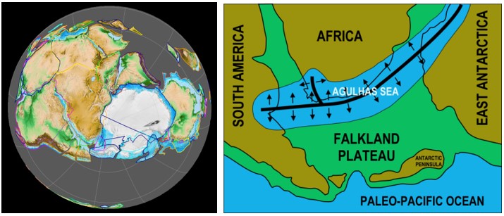
Figure 1a. Supercontinent of Gondwana relative to the South pole. Drawn by Fama Clamosa and reproduced from Wikipedia https://commons.wikimedia.org/w/index.php?curid=67001070 1b. The Agulhas Sea fills the rift valley that developed from south America, across the southern Cape to Antarctica. Reproduced from Wikipedia, Author Oggimus https://commons.wikimedia.org/wiki/File:Southern_Gondwana.png
| Millions of years before present (my) | Environment | Geological activity, rock strata, ecological activity |
| 400-370 my | Deep sea | Agulhas Sea continues to widen and deepen. Rivers deposit fine silts in still deep waters forming the Bokkeveld Group of shales and mudstones that contain fossilized marine invertebrates (trilobites, starfish). The soft chalky pink and yellow shales on the gravel road to the Weltevrede fig farm belong to this group. |
| 370-330 my | Deep sea | Sandy deposits in the Agulhas Sea cover the submarine silts forming the Witteberg Group (mainly quartzite). The Oukloofberg to the south of Prince Albert and the hills on the route from Prince Albert to Oudtshoorn are Witteberg quartzites. |
| 330-290 my | Mountains rise from sea in south Land sags north of fold mountains and an inland sea floods Argentina, the Karoo and Antarctica Glaciers flow into this sea from the north | Stretching of the rift valley containing the Agulhas Sea stopped. The ocean floor to the south of Gondwana began to dip beneath the edge of the continent compressing the sediments in the Agulhas Sea so that they gradually rose, folded and tilted forming the mountains of the Cape Fold Belt (Figure 2B compression). Spectacular folding of quartzite layers in the Swartberg can be seen as you travel through the Meiringpoort or stand on the “dansvloer” at Eerstewater at the northern entrance to the Swartberg Pass. The pressure from the south and the rising of the quartzite sediments to form mountains led to the development of a huge inland depression, the Karoo Sea (Figure 2C – Karoo basin development), to the north of the folding mountains. This sea extended from South America in the East to Antarctica which was then to the West of southern Africa. Glaciers covering the southern Gondwana started to melt as the continent drifted northwards and the mud and rocks deposited by the glaciers in this inland basin (Karoo) form the Dwyka Group. Glacial deposits (or tillite) are thickest (1 km thick) at the southern edge of the Karoo along the inland foot of the fold mountains. The prominent boulders on the Gordon Koppie in Prince Albert are examples of Dwyka tillite and can be seen to include many kinds of rocks picked up by moving glaciers and dropped into the deep Karoo Sea. |
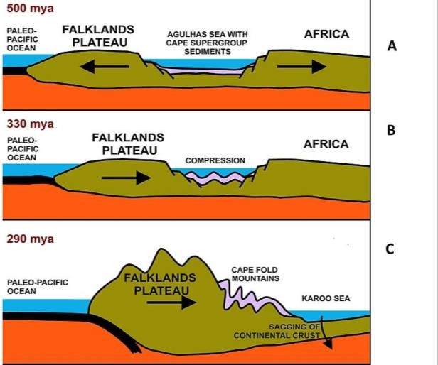
Figure 2. A rift valley forms, widens and is filled with sediments, B. Rift valley is compressed crumpling and lifting the deep sediments to form the fold mountains. C. Presuure causes the land to the north to sag forming the Karoo Sea. Reproduced from Wikipedia. Author Oggmus https://commons.wikimedia.org/w/index.php?curid=31760073
| Millions of years before present (my) | Environment | Geological activity, rock strata, ecological activity |
| 290-260 my | The inland sea gradually fills with sediment carried by rivers from the north | Compression and folding continued as Gondwana floated northwards into warmer latitudes. Rivers draining from the African continent to the north deposited layers of silt over the tillite on the sea floor. The earliest of these layers is the carbon-rich Prince Albert Formation forms the first layer of the Ecca Group and can be seen in the quarry between North end and the hospital. This formation is the source of the fine-grained chert used to make stone tools by Khoi people in this part of the Karoo. The Ecca mudstone, particularly those to the north is dark grey and very carbon-rich – so much so that it contains methane – a flammable gas. Toward the north of the basin – in the vicinity of KZN – layers of coal occur in the Ecca mudstones. The carbon in the Ecca Group originated from forests of Glosopteris a fern-like tree that dominated the vegetation on the coastal swamps to the north of the karoo sea at this time. Fossils of the earliest Gondwana reptile – a freshwater crocodile Mesosaurus – are to be found in the Ecca sediments in both South America and the northern Karoo basin southern Africa. Fossils found in mud deposited in the deep waters where Prince Albert is now located are mainly drift wood and marine animals. |
| 260-190 my | The inland sea is now shallower and filled by sediment from the mountains in the south until only a lake is left A mass extinction then dinosaur evolution | Compression and folding continues and the fold mountains continue to rise. The Karoo seas gradually filled with silt and sand carried northwards from the rising fold mountains to the South. These sandy sediments 7 km thick in places, are the Beaufort Group, and they eventually filled the Karoo Sea reducing it to a lake. As the climate warmed and land replaced the Karoo Sea in the south, the first terrestrial reptiles appeared and diversified in the marshes and shallow seas. Figure 3 shows the position of Prince Albert relative to the sequence of layers of sediments that formed the mountains, hills and rocks we see in the landscape. Around 252 my there was a mass extinction of plants and animals – possibly caused by global warming and oxygen depletion. Destruction of vegetation is thought to have contributed to rapid erosion and accumulation of sediment lays very poor in carbon (devoid of life). Recovery of life over the next 30 million years resulted in a more modern flora and fauna including higher plants, mammal-like reptiles and mammals. Pre-extinction Beaufort sediments include the Abrahamskraal formation approximately 40 km North of Prince Albert on the Kruitfontein road (R353). |
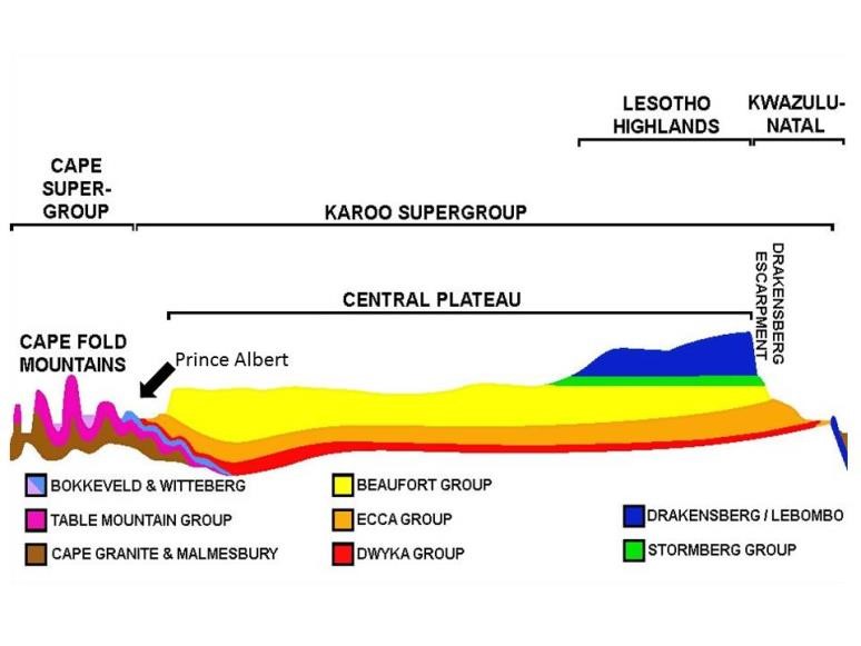
Figure 3. Position of Prince Albert in relation to rock strata from the Cape Fold Mountains to the Drakensburg. Reproduced (with edits) from Wikipedia
| Millions of years before present (my) | Environment | Geological activity, rock strata, ecological activity |
| 190-182 myDesert | Compression and folding continues. A sand desert develops covering the surface of the former sea. | |
| 182-180 m Land buried by lava | Magma pours over much of southern African region of Gondwana. Lava flows form dolerites dykes and saaiklip koppe seen on the escarpment north of Merweville and Beaufort West. | |
| 180-90 my breakup | Gondwana breaks up and sections drift away from Africa o form South America, Antarctica, India, Australia and the Falklands. | |
| 65 my extinction | Meteorite impact causes extinction of 70-80% of all species and the end of dinosaurs. | |
| 55 my-0.4 my Modern life | Global temperatures start to fall. Grasslands replaced forests in many places. Grazing animals evolved. | |
| 0.4-).001 my Homo sapiens | Cool arid conditions interspersed by shorter warm wet cycles about 100,000 years apart. Homo sapiens co-exists with other hominid species. | |
| 21,000-10,000 y Glaciation | A cold arid period known as the Las Glacial Maximum causes ice bergs off Cape Town. Human population is confined to the coast, dry and dusty inland. | |
| 10,000-present warming | Warm wet period. Melting of ice on Cape Fold mountains. Fast flowing rivers erode old land surfaces leaving flat-topped hills covered with river-rolled pebbles. An example can be seen on Gordon Koppie near the beacon as well as to the northeast of Prince Albert on Vyevlei. |
Folding, Faulting and Erosion
The layers of sediment deposited by water in oceans, lakes or on land by wind are further shaped by movements of the Earth’s crust during earthquakes, as well as by erosion of rock and soil by wind and water.
The result of folding or faulting, followed by erosion, is that a single formation or sediment layer does not necessarily continuously cover a land surface. Figure 4 (left) shows how sediments are buckled by folding, and then planed down by erosion to produce a landscape surface showing formations of a variety of ages. Similarly faulting (Figure 4 right) caused by earth quakes and sudden subsidence in a rock layer can cause the layers to change alignment to one another. Erosion then results in a land surface where formations of differing ages may be revealed.
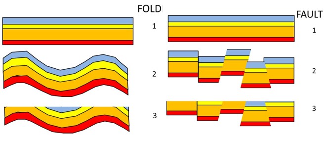
Figure 4. Folding (left) or faulting (right) reshapes the landscape and erosion works to remove projections revealing the older sediments in some places. Graphic by SJM based on McCarthy and Rubidge (2005)
Soil erosion by fast-flowing rivers cuts valleys through layers of rocks (Figure 5a-b). Valleys eventually widen, the river slows down and begins to wind, dropping most of its load of sand, silt and pebbles (Figure 5c-d). The valley eventually fills up with sediments. Following a decrease in sea level or an upward shift in the land mass, the river will be rejuvenated and start to flow rapidly again, cutting into the sediments deposited in the valley (Figure 5e). The surrounding landscape also erodes. Parts of the valley floor that are covered with erosion-resistant cobbles may remain intact while the surrounding valley deposits and rock layers are gradually eroded away. This gives rise to river terraces that form flat-topped hills higher than the surrounding landscape (Figure 5f).
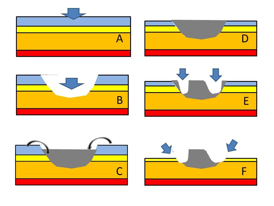
Figure 5. Elevated river terraces form as a result of erosion, deposition and later patchy erosion of the deposited material. Graphic by SJJM based on Oldknow and Hooke (2017)
Descriptions of formations and rocks
The rock formations that can be seen in and around Prince Albert are shown in Figure 6. the For the Cape Supergroup they include the Peninsula, Cedarberg and Kouga formations of the Table Mountain quartzite, the Traka formation of the Bokkeveld Group and the Weltevrede, Witpoort and Kweekvlei formations of the Witteberg group. North from these are Dwka tillite and the Karoo Supergroup comprising the Prince Albert, Rippon, Fort Brown and Waterford formations of the Ecca Group, and the Abrahamskraal and Teekloof formations of the Beaufort Group. Each of these formations will be described and illustrated in this section.
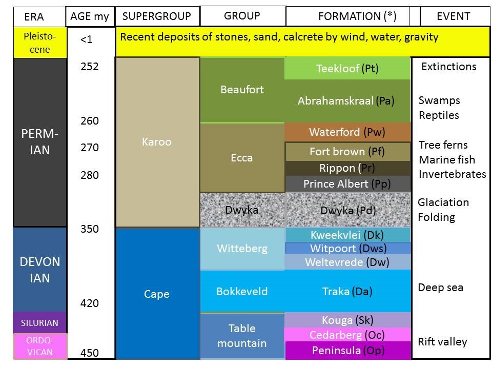
Figure 6. Stratigraphy (rock layers) of the Prince Albert area showing era, age (millions of years), Supergroups, groups, Formations and environmental conditions during deposition or formation. (*) Letters in brackets after Formation name are the abbreviations for these formations as used in the geological map (Figure 7). Graphic by SJM based on McCarthy & Rubidge (2006) and Catuneanu et al (2005) and Gastraldo et al (2020)
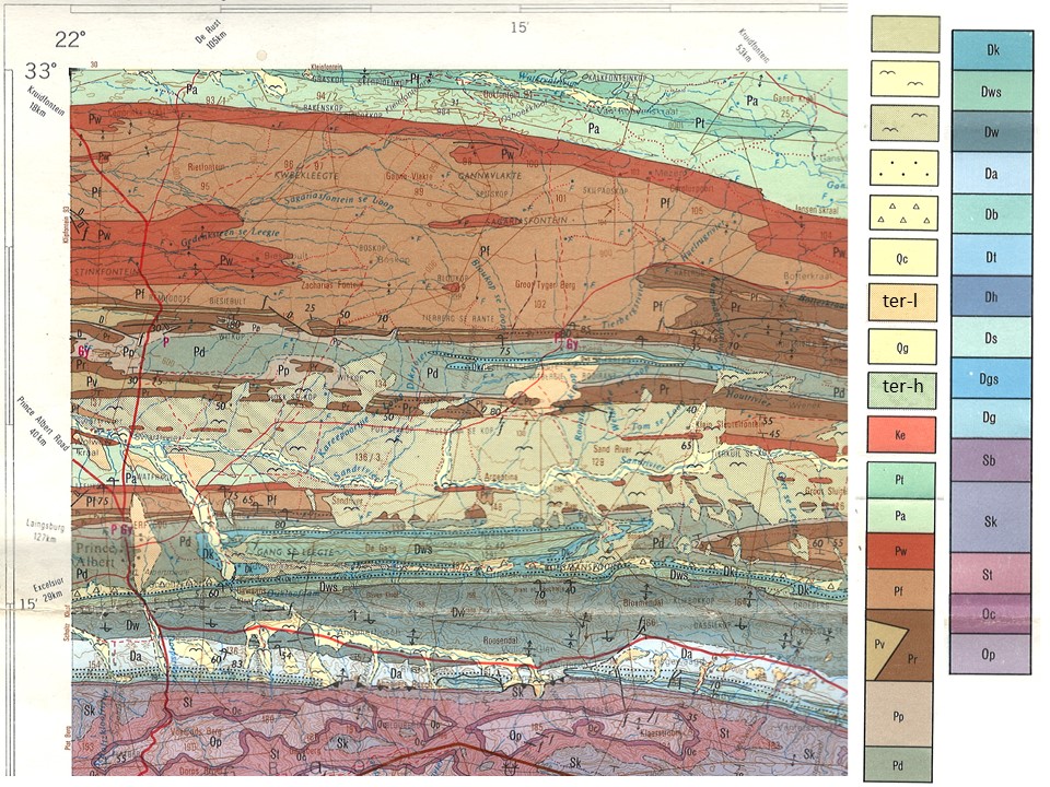
Figure 7. Map of geological formations north, east and south of Prince Albert, showing the east-west trend in the layers exposed by folding and erosion. The oldest rocks – the Swartberg mountains, lie to the South and the younger Karoo Ecca and Beaufort formations to the north of the village. Letters e.g. Pd refer to the various formations names of which area given in full in Figure 6 (Stratigraphy). The flying bird symbol is recent alluvial deposit. Ter-l and ter-h are low and high level river terraces with the1:250,000 Geological Series 3322 Oudtshoorn, Government Printer Pretoria 1979
Cape Supergroup
This comprises table Mountain, Bokkeveld and Witteberg Groups and was deposited more than 350 million years before present in a rift valley when most of southern Gondwana was covered with ice
Table Mountain Group Quartzite
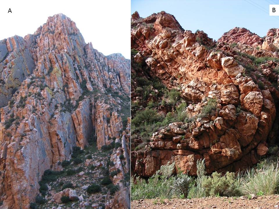
Figure 8. Table Mountain Groups Quartzite (Kouga Formation) near Eerstewater in the Swartberg Pass showing (A) vertical layers and (B) folding (SJM)
Bokkeveld Group siltstones and mudstones
The brown hills on the north side of the Swartberg Pass where the bridge crosses the Dorps River belong to the Bokkeveld series of shales, siltstones and sandstones (Figure 9), probably of the Adolphspoort Formation. The alternating thin and thick deposits suggest an unstable land surface troubled by earth quakes. These relatively soft roacks lie between the Table Mounttain Group quartzites and the Witteberg Group quartzites and sandstones. The road from Prince Albert to Weltevrede follows a valley in this soft rock formation.
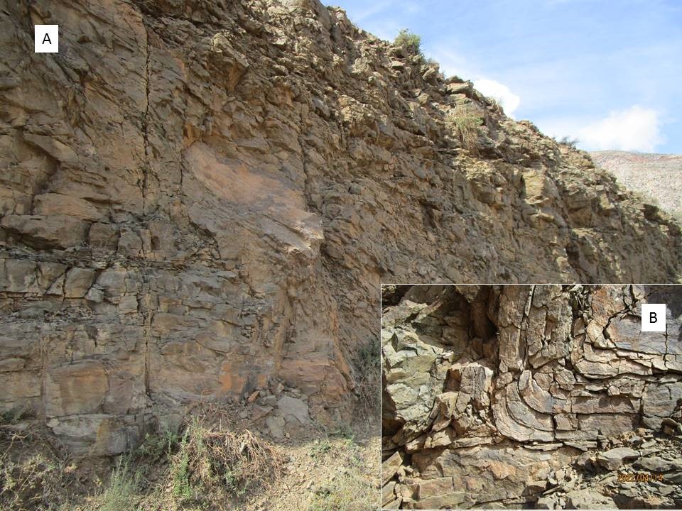
Figure 9. Bokkeveld sand and silt stones of the Adolphspoort Formation near the bridge over the Dorps River on the Swartberg Pass road. Note dark colour and folding (SJM)
Witteberg Group Quartzite, silt stone and sandstone
The reddish-brown much folded rocks seen at the intersection of the Swartberg Pass road with the tar road to Prince Albert belong to the Weltevrede Formation of the Witteberg Group comprising siltstone and sandstone (Figure 10). Near the water purification plant the rock strata are lighter in colour and nearly vertical in alignment (Figure 11). The are probably Witpoort Formation quartzitic sandstone. In places these hard white rock slab overlie soft talus or material deposited by erosion, making the road cutting through them unstable and subject to rock falls.
Trace fossils of early animals (Spirophyton, a filter feeder) and primitive plants washed from the land occur in the Witteberg Group and some have been recorded near Prince Albert (Figure 12).
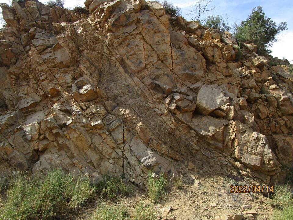
Figure 10 Witteberg Group, Weltevrede Formation 0.5 km after turnoff to Swartberg Pass (SJM)
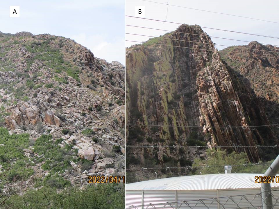
Figure 11. Witteberg Group, Witpoort Formation of the Oukloof range immediately south of Prince Albert near the water purification works. A shows the north-facing slope of white quartzite colonised by spekboom vegetation. B shows the south-facing slope with vertical strata and yellow-green lichen. To the right is the start of the browner Weltevrede Formation of the Witteberg Group (SJM)
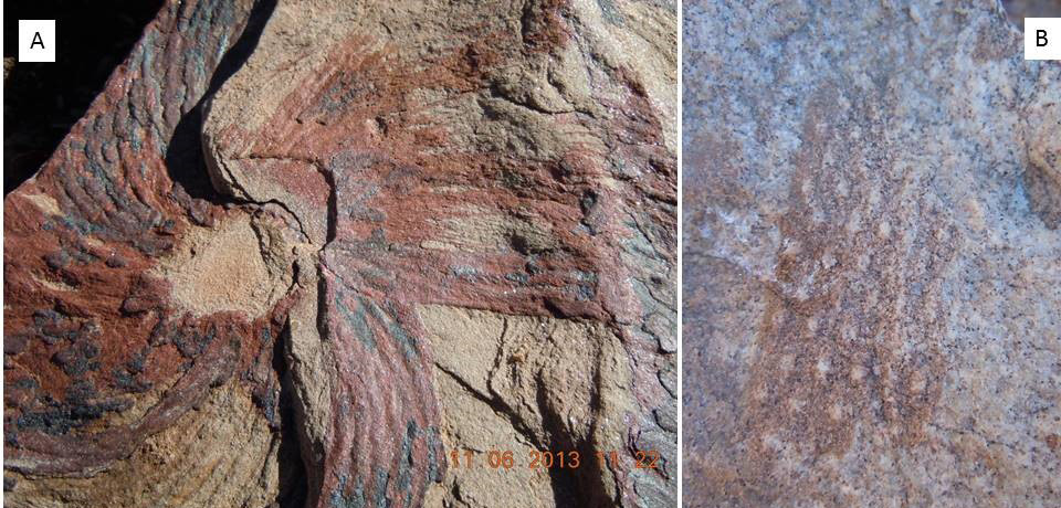
Figure 12. Trace fossil of the primitive animal Spirophyton. B. the impression of part of a plant. Both in Witteberg Group rocks on the farm Baviaanskloof 10 km east of Prince Albert (SJM)
Dwyka Tillite
Dwka tillite (Figure 13) was deposited 300-300 my ago by glaciers and icebergs melting in the deep Agulhas Sea. Dwyka Tillite comprises a blue-grey rock slurry in which is embedded a wide variety of rocks carried from inland Gondwna to the North of this sea. These encased rocks (Figure 13B), also known as dropstones or erratics include granite, quartzite, banded ironstone, limestone and jasper. On the Gordon Koppie above Klip Sreet the tillite appears as brown jutting boulders, and is similar in appearance between Matjiesfontein and Laingsberg. The characteristic shape of Dwyka Tillite landforms is known as gravestone weathering. The boulders are brown on the outside because of oxidation of the iron they contain, but when browken are blue-grey – the colour of the anoxic mud deposited in a deep sea.
Whereas the Tillite emerges as a koppie above Prince Albert, a second outcrop of Tillite 12.5 km north of Prince Albert on the R353 (to Leeugamka) is eroded flat to form a dark-coloured pavement scattered with dropstones of various kinds (Figure 13C).
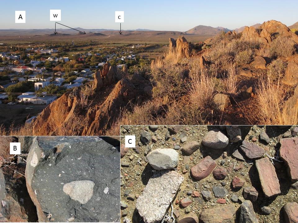
Figure 13. Tillite on Gordon koppie showing “gravestone weathering” that is characteristic of Dwyka Tillite. Ecca Group hills on Waterkop (w) and Cordiersriver (c) can be seen in the background. B shows the inner grey matrix and a variety of small and large stones known as dropstones (or erratics). C an assortment of dropstones on the eroded Tillite pavement 12.5 km North of Prince Albert (SJM)
Ecca Group
In the Prince Albert area, the oldest layer of the Ecca Group is the Prince Albert Formation that lies directly over the Dwyka Tillite. Above this are the Whitehill and Collinham Formations Together these three Formations are 100-200 m thick (Figure 14). The Collinham Formation is capped by an erosion-resistant, fine-grained rock called Matjiesfontein Chert about 0.3 m thick.
The dark grey Prince Albert Formation shale contains lighter yellow and white soft band of volcanic ash indicating periodic volcanic eruptions on the highland to the north from which rivers carried the sediments into a 400 m deep sea. The Whitehill Formation is carbon rich probably as a result of algal blooms, and weathers white (like ash) through oxidation. The three Formations usually support different vegetation types (See Figure 14a). Clearly exposed examples of of this geology can be seen in the quarry north of the Prince Albert Hospital, on the road into Waterkop Estate to the north of the Dorps River crossing, and on the farms Sandrivier and Argentina to the East of Prince Albert.
He Whitehill Formation contains fossils of wood, small marine reptiles and other marine animals including crabs and bony fish (Figure 15).
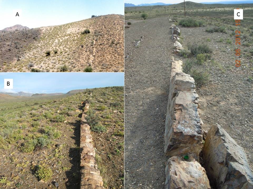
Figure 14. (A) The Prince Albert, Whitehill and Collingham Formations are clearly identifiable on the farm Argentina approximately 25 km east of Prince Albert. The erosion resistant Matjiesfontein Chert band on the northern edge of the Collingham formation is clearly seen on (B) Sandrivier and (C) in the quarry near the Prince Albert Hospital (SJM).
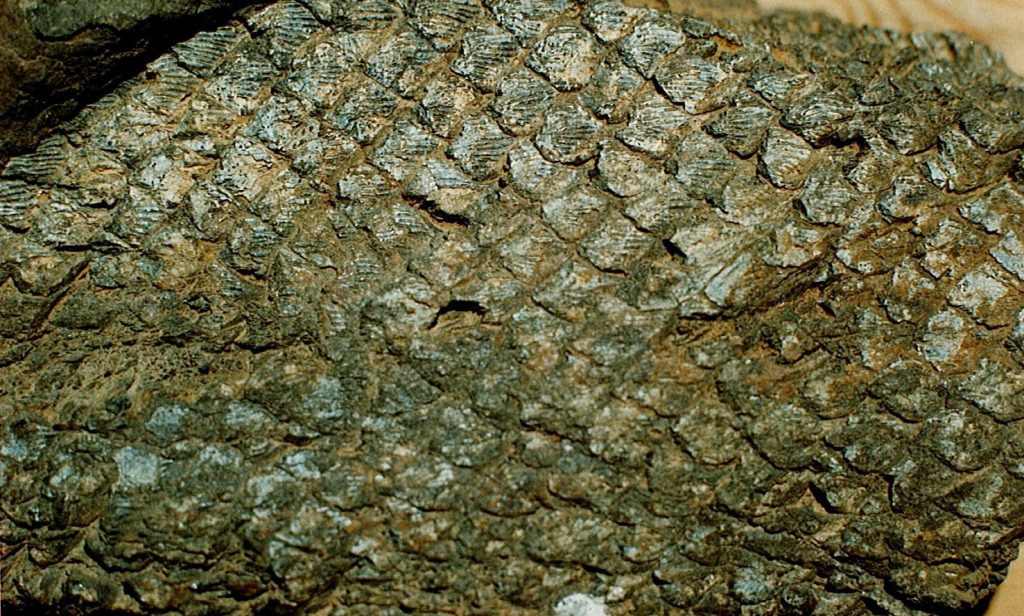
Figure 15 Scales of a fossil bony fish from the Whitehill formation north of the farmhouse on Tierberg 30km east of Prince Albert (SJM)
Overlying the Matjiesfontein Chert are the Rippon, Fort Brown and Waterford Formations of the Ecca Group. All of these are can be seen on Waterkop estate and on the road to Zeekoegat on either side of the Oukloof River crossing. These also dominate the geology of Rietfontein farm on the R353. It may seem illogical that parallel exposures of a single rock formation of a given age and character occur in the landscape some 10 to 20 kilometers apart. For an explanation of this see Figure 5 on the page dealing with FOLDING, FAULTING and EROSION.
The Waterford Formation (Figure 16 and 17) forms the Leeukop ridge on which the name of the town has been written in white stones, and also the Waterkop Ridge on the southern boundary of the Waterkop estate. It reappears again as small koppies on the far side of the Swart River crossing on the R353 (7 km north of the village) and again as a large group of hills on Rietfontein 20 km north of Prince Albert. It comprises thick layers of sandstone interbedded with layers of shale, and is around 800 m thick. Some interesting features include “ball and pillow” structures formed when hard rock falls into soft sediment, various conglomerates and ripple-marked stones indicative of deposition in shallow water. Fossils of worm tubes and burrows are common.
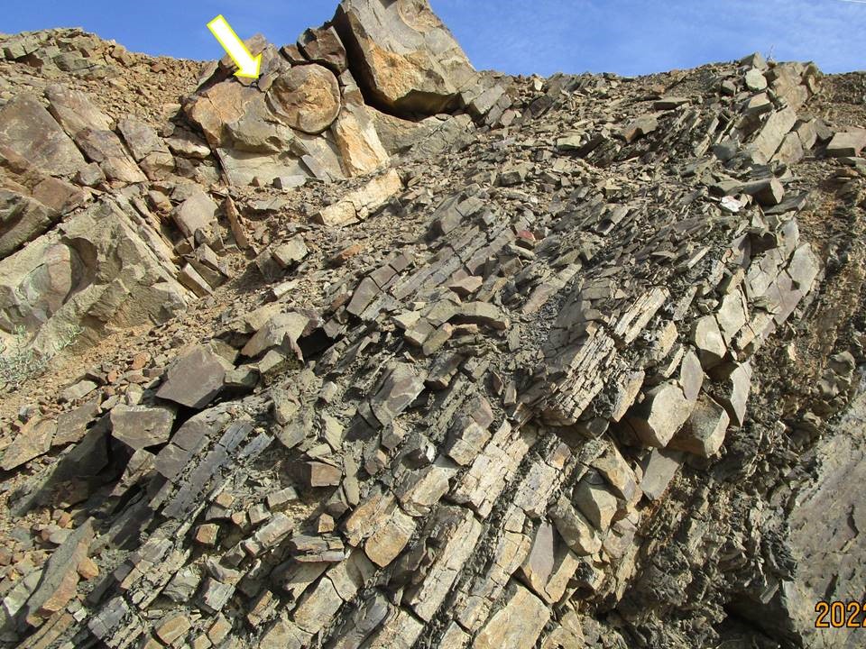
Figure 16. Ecca Waterford Formation: Upper photo taken 4.5 km North of Prince Albert. Arrow indicates “ball and pillow ” deformation (SJM)
Figure 17. Waterford Formation showing (A) ripple marks, (B) river-rolled stones embedded in soft sediment forms a conglomerate rock beneath (C) whitish mottled sandstone (SJM)
Beaufort Group
The Abrahamskraal Formation is the lowest layer of the Beaufort Group and predates the Permian extinction. It is 1500 m thick, vertically orientated, and comprises bluish-grey and reddish-grey fine-grained sndstone (Figure 18) and can be seen on Wolwekraal Nature Reserve 3.5 km north of Prince Albert on the R353, and reappears again 22 km North of Prince Albert along the R353. Layers include thin bands of chert and calcareous nodules.
Vertebrate fossil remains (Dinocephalia) and silicified wood are fairly common. Footprints of the large hippo-like, semi-aquatic, herbivorous reptile Bradysaurus can be seen on this rock formation in a riverbed on the farm Kleinwaterval to the Northeast of Prince Albert (Figure 19).
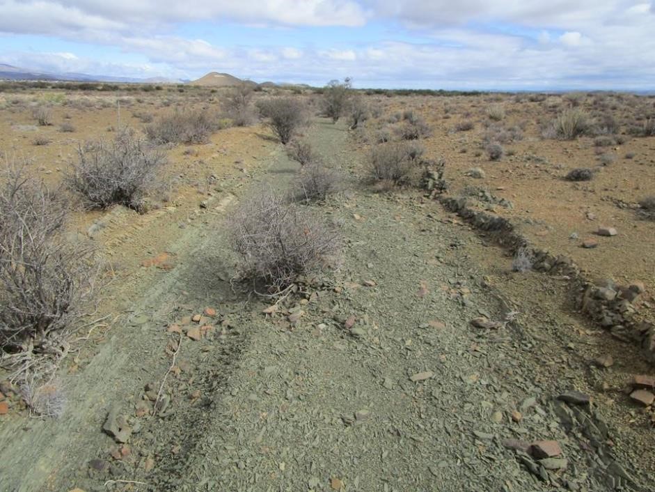
Figure 18. Vertical layers of soft and hard Beaufort Group sandstone and mudstone of the Abrahamskraal Formation on Wolwekraal Nature Reserve North of Prince Albert. Carbon from decayed plant remains gives it the dark grey colour. Note the Leeukop (Ecca Group Waterford Formation) to the southwest (SJM)
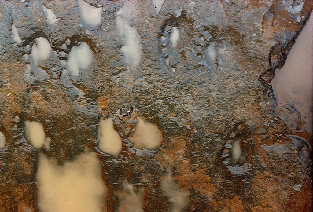
Figure 19. Bradysaurus 5-toed footprints on Beaufort Group mudstone (Abrahamskraal Formation) in a river bed on the farm Kleinwaterval northeast of Prince Albert. This hippo-like reptile lived 260-265 million years ago (SJM)
Recent deposits
Elevated River terraces
The formation of river terrances is described in Figure 6 of Folding, Fauling and Erosion. In the Prince Albert area old terraces of the Sand, Swart and Dorps Rivers are covered with a layer of alluvial quartzite pebbles cemented together witth calcrete or silcrete (Figure 20). This makes them resistant to further erosion so that they remain above the level of the surrounding more eroded landscape.
Sometimes these flat terraces become isolated by erosion of the landscape around tthem. Excellent examples are Platberg on the farm Vyevlei, a smaller flat-topped hill nearer Prince Albert (Figure 21), and the Gordon Koppie above Klip Street. All three of these features are flat quarzite pebble surfaces overlying Dwyka Tillite hills.
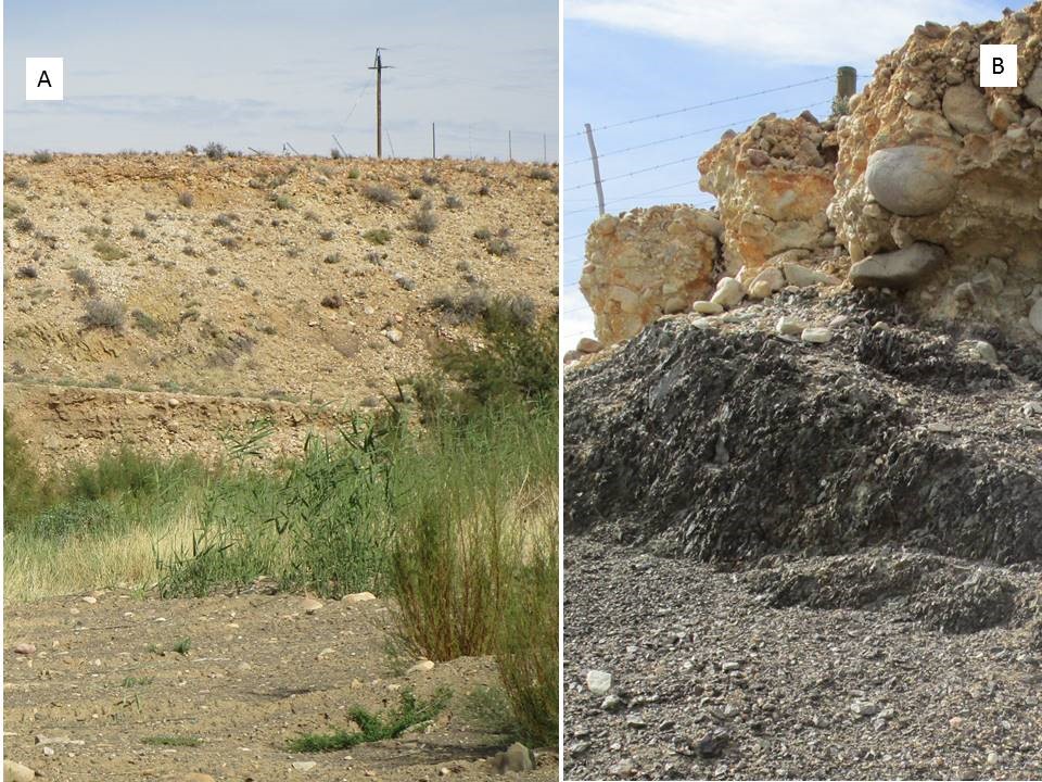
Figure 20 Terrace of the Swartrivier on the R353. The current level of the river is some 10 metres below its original pebble-strewn bed that now forms a cemented terrace on the southern bank
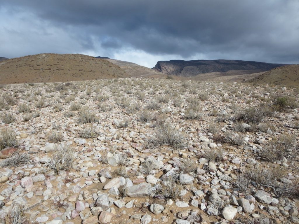
Figure 21. The flat gravelled surface is an elevated river terrace (old land surface) that overlies Dwyka Tillite 3 km east of Prince Albert. Additional examples of such river terraces are the Gordon koppie (near the beacon), and Platberg 6 km east of Prince Albert on the Zeekoegat Road (SJM)
Evaporites, Calcretes, Pedocretes
Soil particles and rocks can be cemented together by calcium, phosphate, iron oxide or silicate that disolves in water and is then deposited as a plaque or cement as the soil dries and the water evaporates. In relatively recent times, i.e. the past 20,000 years, river terrace pebbles, and layers of limestone, gypsum, phosphate, ferricrete and silcrete have formed, often in temporary pans or near the beds of past or present rivers. The pedocretes (or cemented soils) are sought-after materials for surfacing gravel roads as they form smooth stable surfaces. However they are sometimes also of interest to paleobiologists as they can contain fossilized bones, wood and pollen grains as well as archeological artifacts left by people who hunted near pans and river systems.
In the Prince Albert area there are numerous patches of calcrete in river valleys. Many of those near gravel roads have been excavated for road material, transorming them into borrow pits or hollows. Examples can be seen 4 and 7.5 km north of Prince Albert on the R353 as well as on the road to he Gamkaspoort Dam. Depending on the conditions in the water body – such as the presence of peat, dead plants and oxygen in the mud, the dissolved minerals may form white grey or yellow nodules or concretions (Figure 22 B and C). In some cases wood cells may be replaced by calcium carbonate preserving the structure of the wood (Figure 22 A and B).
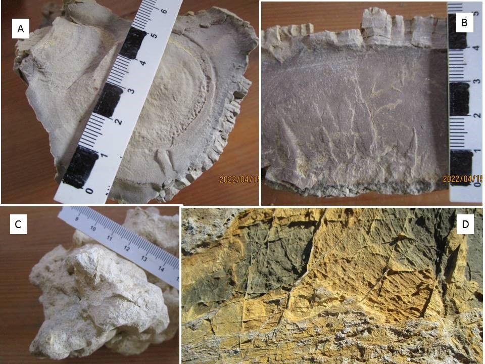
Figure 22. Calcified wood in a limestone evaporite borrowpit North of the Swart River on the R353
Touring the Geology of the Prince Albert area
Exploration ethics
When exploring the eology around Prince Albert please be aware that:
- Fenced properties are privately-owned land. Do not cross fences without permission of the land owner
- All fossils (and archaeological arefacts) in South Africa are protected by law. Their collection or removal without an official permit is a punishable offence!
- When stopping on The Swartberg Pass or in cuttings on narrow roads, please consider other drivers.
Roads through the geological sequences
Cape Supergroup: Swartberg Pass
Cape Supergroup: Weltevrede Road
Cape Supergroup: Road to Klaarstroom
Cape and Karoo Supergroups: Industrial area to Gamkaspoort Dam
Karoo Supergroup: R353
Karoo Supergroup: Zeekoegat Road
Karoo Supergroup: Waterkop Estate (Privately owned erven – permission required to leave road)
Karoo Supergroup: Prince Albert Road
Walks through Geological Formations
Karoo Supergroup and River terrace: Gordon koppie
Karoo Supergroup, Prince Albert formation and Matjiesfontein Chert: Quarry at Hospital
Karoo Supergroup, Waterford and Abrahamskraal. Wolwekraal Naure Reserve (guided tours only)
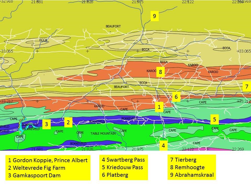
Figure 23 Geology drives – drives and destinations referred to in the text
Further reading and references
Catuneanu O, Wopfner H, Eriksson PG, B. Cairncross, Rubidge BS, Smith RMH, Hancox PJ 2005. The Karoo basins of south-central Africa. Journal of African Earth Sciences 43: 211–253.
Compton J 2021 West Coast – a natural history. Earthspun Books, Cape Town.
Gastraldo RA et al. 2020. The base of the Lystrosaurus Assemblage Zone, Karoo Basin, predates the end-Permian marine extinction. Nature Communications 11:1428. https://doi.org/10.1038/s41467-020-15243-7
King LC 1963 South African Scenery – textbook of geomorphology. Oliver and Boys Ltd, Edinborough. Page 258 ref “gravel-capped terraces at Prince Albert
Linol B, de Wit MJ 2016 Origin and evolution of the Cape Mountains and Karoo Basin. Springer
McCarthy T, Rubidge B 2005 The story of Earth & Life – a southern African perspective on a 4.6 billion-year journey. Struik, Cape Town
Norman N, Whitfield G 2006 Geological Journeys – a traveller’s guide to South Africa’s rocks and landforms. Struik, Cape Town
Oldknow CJ, Hooke JM 2017 Alluvial terrace development and changing landscape connectivity in the Great Karoo, South Africa. Insights from the Wilgerbosch River catchment, Sneeuberg. Geomorphology 288: 12–38.
Toerien DK 1979 The geology of the Oudtshoorn area. Explanation to sheet 3322 (1:250,000). Geological Survey, Department of Mines, Pretoria.
Johnson MR, Keyser AW 1979 The geology of the Beaufort West area. Explanation to sheet 3222 (1:250,000). Geological Survey, Department of Mines, Pretoria.
Web pages
http://palaeos.com/vertebrates/anapsida/pareiasauridae.html#Bradysaurus
Maps
3322AA Prince Albert, 1:50,000 2nd Edition 1982, Surveys and Mapping, Mowbray
3322AB Botterkraal, 1:50,000 2nd Edition 1982, Surveys and Mapping, Mowbray
3322AC Cango Caves, 1:50,000 2nd Edition 1982, Surveys and Mapping, Mowbray
3321BB Gamkarivier, 1:50,000 2nd Edition 1982, Surveys and Mapping, Mowbray
3321BD Kruisrivier, 1:50,000 2nd Edition 1982, Surveys and Mapping, Mowbray